
Gorgie, now a bustling part of Edinburgh, has undergone dramatic changes over the past two centuries.
From its rural beginnings to its industrial heyday and regeneration, the changing faces of Gorgie tells a story of urban change over time.
A time of Industrial expansion
Gorgie comes from the word Gorgyne, which means spacious wedge of land. This was a fitting name, as this area – now part of Edinburgh – was originally farmland and countryside.
It changed significantly during the Victorian Industrial Revolution. Factories, breweries, distilleries and glue works were built, together with rows of tenement housing hemmed in by several railways. Within a few decades, Gorgie was transformed from farmland to a high-density industrial district.
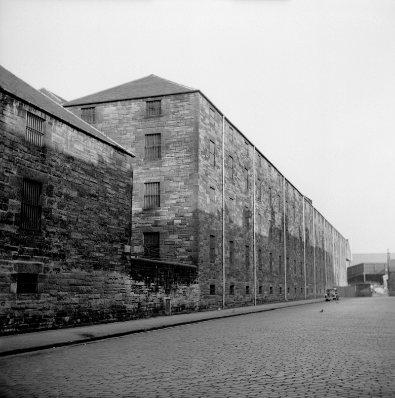
Figure 1 Production at the North British Distillery began in 1887, and the first Saladin maltings in Scotland were installed here in 1948. © HES (Papers of Professor John R Hume, economic and industrial historian, Glasgow, Scotland)
As Gorgie was one of Edinburgh’s first industrial expansion areas, it included an array of buildings that used to house community life and industrial production such as a cinema; viaducts; a Supplementary school; working-class tenements; a wash house and factories. Including the home of the McVitie’s Digestive biscuit!
Similar to many other British industrial hubs, the twentieth century saw a decline in industry. This was reflected in the landscape with the closure and demolition of many of these factories.
These include the Glue Works, a Police Station, White Park Cottages, social housing on McLeod Street, Duty Free Warehouses, and the Great Eastern Laundry. However, there are still many historic buildings that have survived, including nearly all the tenements.
Two Gorgie landmarks are also currently being redeveloped and converted to new use.
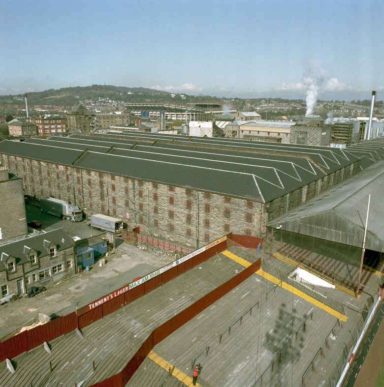
Duty-free warehouses on Wheatfield Place, with the old West Stand of Tynecastle Stadium in the foreground and another historic building on the left. All have since gone but the distillery still operates here today. © HES
The expansion of railways
In 1842, the Edinburgh-Glasgow (North British) railway was built to the north, creating a long boundary cutting Gorgie off from nearby neighbourhoods.
The Caledonian Railway followed in 1848 and the Edinburgh Suburban and Southside Junction Railway in 1885. Both of these cut across Gorgie Road via several bridges. Gorgie quickly became hemmed in by railways and suddenly was a much less spacious wedge of land.
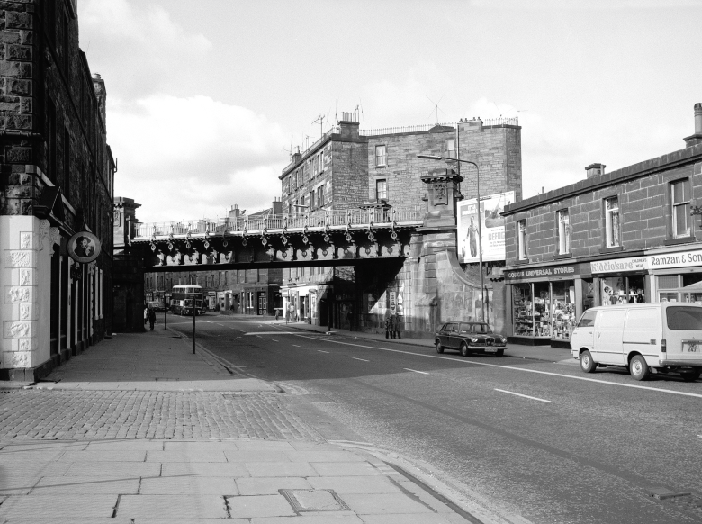
Caledonian Viaduct (Category B listed with outstanding highly decorated details) flies across Gorgie Road. © HES (Papers of Professor John R Hume, economic and industrial historian, Glasgow, Scotland)
Needing to house the workers
Due to this growth of industry, an influx of workers arrived, and they needed to be housed. Rows of four storey tenements were built on the farmland. The flats are small and high density, usually two rooms per flat, and sixteen flats per stair (four flats per floor, each facing one direction: to the front or to the back). They are still here today but have since had bathrooms installed!
Before this expansion, the 1851 Census showed groups of families in isolated farms and cottages. These were usually married couples and their children, working as farm labourers, in the glue works or even as toll keepers.
Only 40 years later, the 1891 Census shows a different picture of a high-density environment with overcrowded tenements. It was not uncommon to have six people or more living in two room houses (flats). Occupations in 1891 included masons, French polishers, quarrymen, sweeps, rubber workers, railway workers, carvers, sculptors, and brewers.
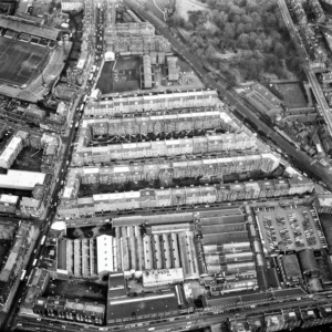
View from above of Gorgie in 1991. Only 34 years ago, but most of the factory at the bottom has been demolished, with flats now in its place. Rows of tenements line Gorgie Road, and ‘the Wardlaws’ at the centre of the image. © HES
The Public Washhouse
Due to the high numbers of people living in small flats, with limited washing facilities, washing and drying was hard to do. To address this, the Council built a series of washhouses in overcrowded sections of the city. This gave a ready supply of hot water and heated drying cupboards.
Gorgie’s public washhouse was built on McLeod Street in 1914 and even included a creche. At its peak, there was an average 52,000 washers in the years 1936-38. Washing was undertaken by the mother of the family, who would stack the family’s washing high into a pram (with the best clothes visible on top!) and wheel it round to one of the washhouses, also known as ‘steamies’.
Here she could wash and dry the laundry in a few hard-working hours, while chatting with friends and neighbours. This was an important part of the neighbourhood and community. However, after washing machines became more affordable and flats were upgraded, the Council no longer wanted to subsidise these facilities and Gorgie’s washhouse closed on 31st March 1977.
It was converted to a community centre in 1981. This was very successful for decades before eventually falling into disrepair and being demolished around 2015. Flats have now been built in its place.
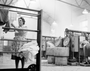
This photograph shows a woman hanging washing out to dry in the public washhouse in McLeod Street in the Gorgie area of Edinburgh. © The Scotsman Publications Ltd.
Planning and The Future
While a lot of demolition has happened, there are some notable listed buildings in the area (you can find out more about what a listed building is here). Although planning permission is granted or refused by the local authority planning departments, we’re consulted by local authorities on many planning proposals for listed buildings. So, what did that look like in the case of Gorgie?
Old Tynecastle High School
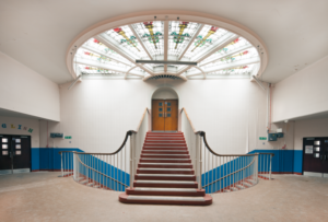
The main stair inside the old school is a major feature, along with the beautiful fan-shaped stained glass roof light above it, bringing lots of light inside. This feature will remain in the finished redevelopment. © HES
As the population grew, so did the need for a school to educate the children of Gorgie. Tynecastle Supplementary School, designed by John Alexander Carfrae, opened in 1912 with around 500 pupils. By 1914, there were 790 pupils.
Tynecastle Continuation (Evening) Classes started for school leavers, where several local firms were involved in some of the subjects. They wanted the students to leave school with the skills that meant they would work for them in the local businesses. The workshops had to open five nights a week as they were so popular.
An early English teacher at the school was Wilfred Owen, the noted war poet. He taught in 1917 whilst recovering from shellshock.
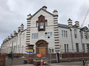
Works are well underway at the old Tynecastle High School. June 2025. © Mathew Reilly
The school sits on a small site, surrounded by former railway embankment (which became the West Approach Road), North British Distillery and Tynecastle Stadium, and had to be extended many times. A new school was built across the road, and they moved there in 2010. The old school was left empty, fell into disrepair and ended up on the Buildings at Risk Register. Plans came forward to partially demolish, extend and convert the buildings into student flats – that’s when we became involved.
We advised that the Janitor’s House and Housewifery block should be retained. Whilst the workshop blocks were reluctantly being demolished, this freed space for new buildings to enable the repair of the main school building. We recorded the site before the works started and the workshop ranges were lost (these were built on the site first to prepare students for the trades in local manufacturing businesses).
Caledonian Brewery
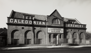
This part of the brewery suffered fire damage in 1994 and was demolished. © HES
Established in 1869 for Lorimer & Clark, the Caledonian Brewery went through many changes and phases of expansion on the site, before finally closing in 2022. It was Edinburgh’s last functioning brewery in the city. There was a fire in 1994 which resulted in many parts being demolished and rebuilt. The plan is to redevelop the site into 168 residential flats, including affordable homes. While some of the buildings were demolished, others were redeveloped.
So how do we advise on what should or shouldn’t be demolished?
Well, we assess applications on a case-by-case basis. In the case of the brewery, there had been many phases of development. Some were modern, altered or of later construction.
We welcomed the retention of the oldest, more historically significant and characterful parts of the brewery. We felt similarly about the new works taking inspiration from the buildings lost to the fire and the materials used, while also reinstating the historic footprint, pend and elevation to Slateford Road.
For this case, we accepted the demolition of later, less significant parts of this complex site, to enable its redevelopment. New blocks of flats will be built in place of the later keg store and modern buildings. The reuse of the site secures its future, whilst retaining its character as a former brewery.
For more information about how change to the historic environment is managed, see our series of guidance: Managing Change in the Historic Environment.
Conclusion
Gorgie has experienced many changes over the last 200 years. From quiet rural farms outside the city, to Edinburgh’s first hub of industrial expansion, to its eventual industrial decline.
As businesses outgrow their sites and decide to move out of the city for more space, they leave these impressive landmark buildings behind. How we can preserve these significant buildings, while meeting the future demands of urban areas is an ongoing challenge. Advising local authorities is one way in which we support this process.
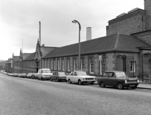
St Andrew Biscuit Works, aka the McVitie & Price factory, which later became Ferranti. This part, the office block, is all that is left of the site, and is a Category C listed building. It was converted to flats in the 1990s when the factory was demolished. © HES (Papers of Professor John R Hume, economic and industrial historian, Glasgow, Scotland).
Find out more
Interested in learning more about Edinburgh’s history? Dive into the changing face of Princes Street, or find out about Ebenezer James MacRae: the man who transformed Edinburgh.
You can also find out more about our role in the Scottish planning system here.